
What if a promising subsurface image still couldn’t confirm that oil or gas is there? That’s the central challenge behind conventional petroleum exploration methods: each technique reveals part of the picture, but no single survey proves a commercial discovery. Geology helps identify settings where petroleum systems may exist, while geophysical and geochemical evidence can refine the search without removing uncertainty.
To assess exploration claims, look at how the evidence builds. Operators compare clues from multiple methods, assess whether a prospect’s geological elements appear to align, and weigh the remaining risks before deciding whether to drill. A model may support a drilling decision, but only a well can directly test the target underground.
This article explains what geological, geophysical, geochemical and drilling methods can reveal, and where their limits lie. Follow the process from regional screening to prospect evaluation and subsurface testing, and see why uncertainty remains until the target is drilled.
Key Takeaways
- Conventional petroleum exploration methods help assess whether subsurface conditions may support recoverable oil or gas, but they cannot guarantee a discovery or commercial production.
- Compare geological mapping, existing well data and geophysical surveys by the type of evidence each provides, rather than treating them as interchangeable.
- Use geochemical indicators, well logs, cores and pressure data to build a more complete picture of subsurface conditions and identify what remains uncertain.
- Trace how exploration progresses from regional screening to prospect definition and evidence integration, with each stage informing whether further work is justified.
- Understand how method selection depends on the geological question, available evidence and stage of resource development in a Canadian context.
What Conventional Petroleum Exploration Methods Are Designed to Find
Conventional petroleum exploration assesses subsurface conditions to determine whether oil or natural gas may have accumulated in a form that could potentially be recovered. The objective is not simply to identify a promising geological shape. Operators assemble and test evidence about the petroleum system, then assess what remains uncertain before deciding whether more work is justified.
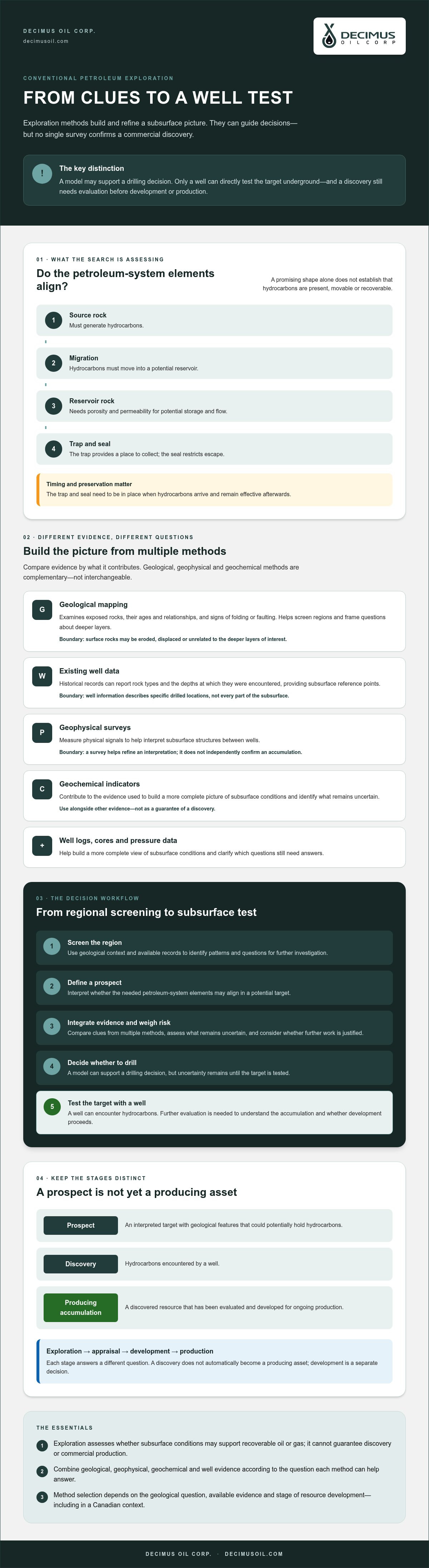
In brief: A prospect is an interpreted target with the geological features needed to potentially hold hydrocarbons. A discovery is hydrocarbons encountered by a well. A producing accumulation is a discovered resource that has been evaluated and developed for ongoing production. These terms represent different levels of evidence and decision-making, not interchangeable descriptions of success.
What makes a subsurface feature a petroleum prospect?
A conventional prospect depends on several elements aligning. A source rock must generate hydrocarbons, which can migrate into a porous, permeable reservoir rock. A sealing layer must restrict their escape, while a geological trap provides the geometry in which they may collect. Timing and preservation matter too: the trap and seal need to be in place when hydrocarbons arrive and remain effective afterwards.
Geologists and geophysicists infer these elements from available evidence. As the overview of Hydrocarbon exploration describes, a prospect is built around petroleum-system components such as source, reservoir and trap, along with the risks of whether those components occur together as interpreted. A mapped structure may look favourable, but its shape alone cannot establish that hydrocarbons are present, movable or recoverable. Until a well tests the target and the results are evaluated, the interpretation remains a prospect.
How conventional exploration differs from production and recovery
Exploration screens for and defines potential targets. If a well encounters hydrocarbons, appraisal may follow to improve understanding of the accumulation, including its extent and characteristics. Development is a separate decision stage: it considers whether and how to establish the facilities and wells needed to produce the resource. Production begins only after a discovery has been evaluated and development proceeds; a discovery does not automatically become a producing asset.
Conventional accumulations are generally sought in reservoir rocks where hydrocarbons have migrated and become trapped. Unconventional development approaches typically target hydrocarbons in less permeable formations, where additional techniques may be needed to enable flow. The distinction concerns the geological setting and development approach, not whether the resource is oil or gas.
Enhanced oil recovery belongs later in the asset lifecycle. It concerns methods for supporting recovery from an existing field, rather than identifying an unexplored prospect. For a separate overview, see enhanced oil recovery techniques. Keeping exploration, appraisal, development and recovery distinct helps clarify what each decision can establish and what evidence is still missing.
Geological and Geophysical Methods Build the Subsurface Picture
Exploration teams combine observations and measurements to develop a model of what may lie below the surface. Geological mapping provides context, existing well records offer direct evidence from previously drilled locations, and geophysical surveys measure physical signals that help interpret structures between wells. Each method answers different questions; none independently confirms a hydrocarbon accumulation.
Geological mapping and regional screening
At the screening stage, geologists examine exposed rocks, their ages and relationships, and evidence of folding or faulting. They may compare these observations with historical well records, including reported rock types and the depths at which they were encountered. This helps identify geological patterns and frame questions for further investigation, such as whether a potential reservoir or structural feature may continue beneath covered ground.
Surface rocks are only a guide. They may be eroded, displaced or unrelated to the deeper layers of interest. Well information offers a subsurface reference, but describes conditions at specific drilled locations, not every point between them. Regional interpretation connects these partial clues while keeping their limitations in view.
Seismic, gravity and magnetic surveys
Seismic reflection surveys send energy into the ground and record returning waves. Changes in the waves’ travel and reflection patterns help interpreters map contrasts between subsurface layers and estimate their geometry. The resulting image is an interpretation of rock boundaries and structures, not a direct view of oil or gas. Gravity and magnetic surveys measure variations in gravitational and magnetic fields, respectively. These indirect signals can help investigate broad structural patterns, but their geological meaning must also be interpreted.
The usefulness of any resulting model depends on the question being asked, the quality and resolution of the data, and the assumptions used to interpret it. In practical terms, compare the methods this way:
- Geological mapping: Observes exposed rocks and structural relationships; supports regional screening; may not represent deeper conditions.
- Existing well information: Records rock and formation evidence at drilled locations; anchors interpretation; coverage is limited to wells and available records.
- Seismic reflection: Measures returning wave responses; helps map subsurface layers and structures; does not directly detect or prove hydrocarbons.
- Gravity and magnetic surveys: Measure variations in physical fields; help assess broad subsurface patterns; signals are indirect and can support more than one interpretation.
These conventional petroleum exploration methods are most useful when their evidence is compared, rather than treated as conclusive on its own. In Canada, Decimus Oil Corp.'s conventional oil and gas exploration focus connects exploration with broader resource development.
Geochemical Evidence and Exploratory Wells: What Can They Confirm?
Geochemical evidence can indicate that petroleum-related compounds or source rocks are present, while a well provides a direct test of the subsurface at a particular location. These forms of evidence answer different questions. Neither a surface seep nor a seismic interpretation proves that a commercial accumulation exists. A seep may show that hydrocarbons reached the surface, but it doesn’t establish the size, quality or recoverability of a subsurface resource.
Geochemical methods and petroleum indicators
Geochemical analysis can examine traces of hydrocarbons in surface samples or assess the composition and maturity of source rocks. Results may help teams evaluate whether a petroleum system could have generated and moved hydrocarbons. Their significance depends on where samples came from, how they relate to the target and whether other evidence supports the same interpretation.
An indicator is a clue, not a verdict. Hydrocarbon traces don’t establish that a reservoir contains a sufficient volume, that fluids can flow, or that development would be commercially viable. Geochemistry is most useful when considered alongside geological and geophysical interpretations, rather than treated as proof on its own.
Drilling, well logs and core samples
An exploratory well tests a geological model by reaching the target and collecting evidence from the rocks encountered. It is a direct subsurface test, but requires substantial capital and still examines conditions at a specific location. Results can support the interpretation, prompt teams to revise it, or fail to find the predicted reservoir or hydrocarbons.
Measurements and samples provide complementary details:
- Drilling results document the formations encountered and whether hydrocarbons were present in the well.
- Well logs record measurements taken in the borehole. Interpreted together, these can help assess rock properties and possible fluid content.
- Core samples are sections of rock recovered from the well. Examination can reveal features such as porosity and permeability, which influence how fluids may be stored and move.
- Pressure data can help characterize subsurface conditions and fluid behaviour within a formation.
Each measurement has limits. Logs are indirect readings that require interpretation; cores sample only the rock recovered; and pressure measurements represent specific test conditions and locations. A positive well result is therefore not, by itself, a complete commercial assessment. Teams must evaluate the evidence alongside the accumulation’s extent, fluid characteristics, development requirements and economic context.
Confirmation comes from integrating multiple lines of evidence, because each method tests a different part of the subsurface model and leaves some uncertainty unresolved. That principle is central to conventional petroleum exploration methods: a well can materially strengthen or weaken a prospect assessment, but decisions about appraisal and development require broader evaluation.
How Conventional Exploration Methods Work Together in a Decision Workflow
Exploration advances through decision gates, not a fixed sequence that automatically ends in drilling. At each stage, teams combine evidence, identify unresolved questions and decide whether another step is warranted. Geological understanding may suggest where to look, but data quality, access, technical feasibility and the potential to develop a resource also influence what happens next.
From initial screening to a testable prospect
A prospect is a testable interpretation, not a confirmed accumulation. The workflow below shows how conventional petroleum exploration methods can refine that interpretation while keeping uncertainty visible:
- Screen the region. Review geological understanding, existing well records and other available information to identify areas that merit closer assessment.
- Define the geological question. Determine which parts of the subsurface model need better evidence, such as the continuity of a rock layer or the presence of a structural feature.
- Gather and interpret data. Use mapping and suitable geophysical surveys to develop a model. Consider what each measurement supports, its limitations and the quality of the underlying data.
- Integrate evidence and define the prospect. Compare the interpretation with well information and any relevant geochemical evidence. Assess whether the geological elements appear to align, and document the remaining risks.
- Decide whether to drill or do more work. Weigh the prospect’s technical case alongside access, feasibility and economic considerations. Further analysis, a revised interpretation or no additional work may be more appropriate than drilling.
How evidence informs the decision to drill
As evidence accumulates, it can strengthen, weaken or reshape a prospect. For example, if a new interpretation changes the estimated geometry of a target, the team may revisit whether the available data adequately support a well location. If the evidence does not resolve a key uncertainty, additional analysis may be considered. Completing a survey alone doesn’t trigger drilling; drilling is a separate commitment to test the model directly.
Even a technically compelling prospect must be considered in the context of resource development. Economic evaluation is a distinct part of that decision process; see this overview of oil and gas exploration economics. In Canada, the wider resource-development context also shapes how technical potential is assessed. Explore the broader discussion of WCSB resource development.
To understand how exploration fits within a Canadian operator’s wider focus, review Decimus Oil Corp.’s resource-development focus.
What Exploration Methods Mean for Canadian Conventional Resource Development
In Canada, selecting an exploration method starts with the question an operator needs to answer. Early screening may draw on existing geological information, while a defined target may call for more detailed subsurface interpretation or a well test. The project stage matters too: evidence useful for identifying a prospect may not be sufficient to support appraisal or development planning.
How operators turn exploration evidence into development choices
Interpreted evidence can guide the next decision, but it doesn’t determine the outcome on its own. A well result that supports the geological model may justify appraisal to better understand the accumulation. Later analysis may inform development planning. If evidence weakens the interpretation, or remaining uncertainties cannot be resolved, an operator may revise the model or stop work.
Technical confidence and commercial viability are related, but distinct. Evidence may support the presence of hydrocarbons without establishing that an accumulation can be developed commercially. Development decisions also don’t guarantee particular production performance. The progression from exploration to resource development depends on what the evidence establishes at each stage, as well as project-specific feasibility and economic evaluation.
Decimus Oil Corp. is a Canadian energy company focused on conventional oil and gas exploration, resource development, energy infrastructure and enhanced oil recovery. Decimus Oil Corp. is publicly traded on the TSX Venture Exchange as TSXV:WCSB, providing an investment opportunity in the energy sector, but company-level information does not establish which conventional petroleum exploration methods are used or imply specific projects, discoveries or results.
A practical reader checklist for evaluating exploration claims
Use these questions to distinguish measured evidence from interpretation and development claims:
- What produced the evidence? Identify whether it came from geological mapping, a geophysical survey, geochemical analysis or a well. Ask what the method actually measured.
- What does the claim describe? A prospect is an interpreted target; a discovery refers to hydrocarbons encountered. Reserves and producing assets are different categories, so check how the company defines and supports its statement.
- What remains uncertain? Look for whether the evidence establishes only a geological interpretation or also supports further appraisal and development decisions.
- Is this a company disclosure or general industry explanation? Keep verified, company-specific statements separate from descriptions of methods used across the sector.
Reading exploration claims with these distinctions in mind helps put technical evidence into its proper resource-development context. For information about the company, explore Decimus Oil Corp..
Evaluate the Evidence, Then Look Ahead
Conventional petroleum exploration methods build a case from multiple forms of evidence, each with a distinct purpose and limitation. Geological interpretation and geophysical surveys help define a possible target, while geochemical indicators and exploratory wells add further evidence. No single result guarantees a commercial discovery: appraisal and development decisions depend on how well the findings support the subsurface model and the project’s broader feasibility.
That evidence-led process connects exploration with Canada’s wider resource-development decisions. Decimus Oil Corp. is a Canadian company focused on conventional oil and gas exploration and resource development. The company’s team has over 100 years of combined experience, and Decimus Oil is publicly traded on the TSX Venture Exchange as TSXV:WCSB.
To learn more about Decimus Oil Corp.’s conventional exploration and resource-development focus, explore Decimus Oil.
Frequently Asked Questions
What are conventional petroleum exploration methods?
Conventional petroleum exploration methods assess whether geological conditions may support an oil or gas accumulation that can be tested and potentially developed. They include geological interpretation, geophysical surveys, geochemical analysis and exploratory drilling. Each contributes a different type of evidence: seismic data can help map subsurface structures, while drilling directly tests a specific location. No single method confirms commercial viability. Operators consider the combined evidence, well results, technical requirements and economic factors before making further decisions.
How does seismic surveying help find petroleum?
Seismic surveying records how waves travel through and reflect from underground rock layers. Geoscientists interpret the recorded responses to build images of subsurface structures and identify features that may warrant further investigation. For example, an interpreted shape may suggest a geological trap. Seismic data doesn’t directly show oil or gas, however, and the interpretation can remain uncertain. Additional evidence, potentially including an exploratory well, is needed to test whether the subsurface model is supported.
Can a seismic survey confirm an oil or gas discovery?
No. A seismic survey can help map subsurface structures and refine a geological interpretation, but it cannot alone confirm a recoverable petroleum accumulation. Exploratory drilling may test the interpretation, while well logs, rock samples and other measurements help characterize the formations and fluids encountered. Even when a well confirms hydrocarbons, further assessment is needed to understand the accumulation and evaluate whether development is technically and commercially viable. A discovery does not automatically mean production will follow.
What happens after an exploration prospect is identified?
After a prospect is identified, the operator evaluates the available geological, geophysical and other evidence to decide whether further work is justified. This may involve refining the subsurface model, collecting additional data or considering an exploratory well. The next step depends on unresolved uncertainty, technical feasibility, access and economic factors. A prospect isn’t automatically drilled, and drilling doesn’t guarantee a discovery. If new evidence weakens the interpretation, the operator may revise it or stop work.
What is the difference between conventional and unconventional petroleum exploration?
Both approaches assess subsurface geology, but they target different types of hydrocarbon accumulation and may lead to different development strategies. Conventional exploration typically evaluates whether oil or gas has accumulated in reservoir rock and may flow under suitable conditions. Unconventional resources are generally associated with formations that require different extraction strategies. These categories aren’t interchangeable, and the distinction depends on the specific geology and project design, rather than simply whether the target is oil or natural gas.
Are geochemical methods enough to prove petroleum is underground?
No. Geochemical analysis can identify or assess hydrocarbon traces and characteristics of source rocks, but it provides only one part of the evidence. It doesn’t establish that a suitable reservoir and seal exist, or that an accumulation is recoverable commercially. Geoscientists compare geochemical findings with geological and geophysical interpretations to assess whether the evidence supports a petroleum system. Even a positive indicator may require further investigation, including direct testing, before the subsurface conditions are better understood.
Why do exploration companies use several methods instead of one?
Exploration companies use several methods because each measures or interprets different aspects of the subsurface. Geological mapping provides context, geophysical surveys help interpret structures, geochemical analysis may reveal indicators, and drilling tests a model at a specific location. Comparing these lines of evidence can strengthen an interpretation or expose gaps that one dataset alone might miss. Uncertainty remains, since the subsurface can’t be known completely before testing and no method guarantees a commercial outcome.


