
Offshore western Canada is not one continuous petroleum system. Sedimentary basin hydrocarbon exploration examines how basin structure, source rocks, thermal maturity and migration interact in areas such as the Queen Charlotte, Hecate, Georgia, Winona and Tofino basins. In the Queen Charlotte Basin, the Kunga and Maude groups are principal oil source rocks. The Doig, Nordegg and Ordovician examples help show how geologists assess source-rock evidence across western Canada.
Source-rock presence is only one part of the exploration picture. The rock must also reach suitable maturity, generate hydrocarbons that can migrate, and connect with reservoir and seal conditions that support accumulation and preservation.
This overview explains how Doig and Nordegg source rocks, Ordovician oil chemistry, maturity and migration inform petroleum-systems analysis, then sets those factors in the geological context of British Columbia’s offshore basins. Together, these examples show how evidence from different geological intervals contributes to an integrated view of exploration potential.
Key Takeaways
- Assess source-rock evidence in context: stratigraphic position and oil correlations help distinguish potential hydrocarbon contributions.
- Use maturity and organic-carbon evidence to evaluate whether source rocks could have generated hydrocarbons, including in the Nordegg interval.
- Interpret oil chemistry, migration pathways and structural connections together to understand how source rocks may relate to accumulations.
- Compare offshore basin architecture, depositional environments and potential source-reservoir-seal relationships to frame exploration prospects.
Doig Formation source rocks and oil correlations
In the Western Canada Sedimentary Basin, evidence from the Doig Formation’s marine deposits helps geologists assess hydrocarbon generation and potential oil relationships.
Doig Source Rock Characteristics
The basal Doig Formation contains marine phosphatic siltstones identified as Middle Triassic source rocks. With sufficient burial and heating, their organic matter can transform into mobile hydrocarbons. Exploration teams assess how these source intervals relate to maturity, migration pathways and suitable reservoirs. The formation’s position in the basin provides a stratigraphic reference for comparing these elements across a petroleum system.
Oil Correlation Methods
Oil correlation compares the geochemical characteristics of sampled oils with those of candidate source rocks, including the Doig interval. The aim is to assess whether oils may share a source, rather than relying on location or reservoir age alone. Stratigraphy, maturity and possible migration routes provide essential context. Correlation can help geologists link a source interval to a reservoir, but remains one part of a broader petroleum-system assessment.
Conventional exploration targets hydrocarbons that have migrated into porous, permeable reservoir rocks and accumulated beneath a seal. Unconventional exploration instead targets hydrocarbons retained in organic-rich formations or low-permeability zones, rather than in a discrete conventional pool.
Seismic surveys send energy into the subsurface and interpret returning reflections to map rock layers and structures. Exploratory drilling tests the interpreted target, while well logs and rock samples provide direct evidence about the formations encountered.
Resource estimates combine geological mapping, reservoir properties and hydrocarbon volumes, using methods such as volumetric analysis. To assess discovery probability, geologists evaluate whether the essential petroleum-system elements align: source, maturity, migration, reservoir, seal and trap. For a Doig prospect, this helps distinguish evidence of source rock from evidence for a recoverable accumulation.
Nordegg Jurassic source rocks and maturity
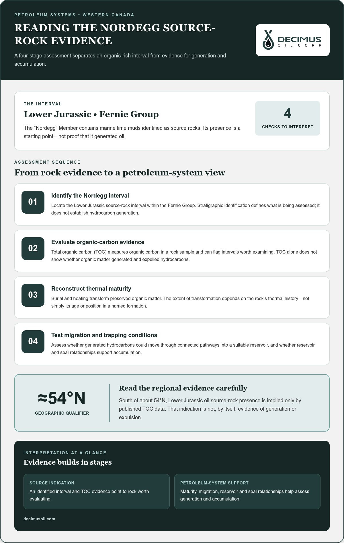
The “Nordegg” Member belongs to the Fernie Group and contains marine lime muds identified as Lower Jurassic source rocks. This gives exploration teams a specific interval to assess within the Western Canada Sedimentary Basin. Source-rock presence is a starting point, not proof that the rock generated oil. Its organic content, burial history and thermal maturity shape the interpretation.
Geographic evidence requires careful reading. South of about 54°N, the presence of Lower Jurassic oil source rocks is implied only by published total organic carbon data. Total organic carbon, or TOC, measures organic carbon in a rock sample. It can help identify intervals worth examining, but TOC alone does not show whether organic matter generated and expelled hydrocarbons. The distinction matters when translating a regional indication into a prospect-level assessment.
Maturity is the next part of the evaluation. As sedimentary rocks are buried, increasing heat can transform preserved organic matter into hydrocarbons. The extent of this transformation depends on the rock’s thermal history, not simply its age or position in a named formation. Geologists therefore interpret evidence from the Nordegg interval alongside its burial and heating history before assessing its capacity to generate oil.
Exploration analysis also considers whether hydrocarbons generated in the Nordegg source interval could migrate into a reservoir. Migration depends on connected pathways through surrounding rocks; accumulation requires a suitable reservoir and seal. These elements help distinguish evidence of a possible source from a complete petroleum-system interpretation. A mapped Nordegg interval becomes more significant when its maturity and geological relationships support the other required elements.
For readers assessing a Lower Jurassic prospect, the sequence is to identify the Nordegg interval, evaluate TOC evidence, reconstruct thermal maturity, then examine migration and trapping conditions. Each step answers a different question. Together, they help separate an indication of organic-rich rock from evidence that supports hydrocarbon generation and accumulation. South of about 54°N, that distinction is especially important because the source-rock presence is inferred from TOC data.
Ordovician source rocks, maturity, oil chemistry, and migration
Ordovician marine kukersites occur in several Western Canada Sedimentary Basin formations. Their significance depends on maturity, hydrocarbon generation, migration pathways and preservation.
Ordovician Source Rocks and Maturity
Ordovician marine kukersites occur in the Stony Mountain, Herald, Yeoman and Winnipeg formations. These organic-rich rocks are potential sources, but their presence alone does not establish whether they generated hydrocarbons. Burial and heating determine maturity, which influences whether organic matter can produce oil or gas. Exploration analysis therefore considers source-rock distribution and thermal history, then evaluates whether generated hydrocarbons could reach suitable reservoirs.
Oil chemistry provides another line of evidence. In the Western Canada Sedimentary Basin, oils in Viking and younger sands are sourced from Colorado Group shales and usually contain less than 0.4 percent sulphur by weight. This example shows how oil properties and stratigraphic relationships can help assess source correlations. It does not establish a connection to Ordovician kukersites. Comparing a candidate oil with its geological setting helps distinguish plausible source relationships from simple proximity between source and reservoir.
Hydrocarbon Migration
Migration is the movement of generated oil or gas from source rock through surrounding formations toward a reservoir. For Ordovician intervals, maturity indicates whether hydrocarbons could have formed, while geological pathways help explain where they might have moved. Faults and connected rock layers can influence migration routes; reservoir and seal conditions affect accumulation and preservation. Each factor contributes evidence to the petroleum-system interpretation.
The Fort St. John Graben offers a separate maturity example: gas occurrences in the Wabamun-to-Belloy section were attributed to the Exshaw at advanced maturity. This illustrates why source attribution and maturity must be evaluated together. Two-dimensional or three-dimensional petroleum-systems models can assess migration efficiency by integrating geological structure, source-rock properties and timing. The interpretation can help clarify whether hydrocarbons may have migrated from a source interval and reached a viable accumulation, rather than remaining dispersed or escaping preservation.
In the U.S. portion of the Williston Basin, faulting and folding connect Ordovician source rocks to multiple reservoirs. In the Queen Charlotte Basin, source rocks in the Kunga and Maude groups have total organic carbon values up to 11%. Petroleum systems analysis considers hydrocarbon generation, migration, accumulation, and preservation.
Geologic setting of offshore western Canadian basins
British Columbia’s offshore basins differ in age, structure and sedimentary succession. Their geology shapes how exploration teams evaluate relationships among source, reservoir, seal and trap across domestic frontiers, aligning with nationwide resource assessment standards.
British Columbia’s offshore basins include Queen Charlotte, Hecate, Georgia, Winona and Tofino. Geological setting alone cannot rank these basins; prospectivity depends on how petroleum-system elements align in each area. The Queen Charlotte Basin illustrates this complexity through its varied volcanic and sedimentary sequences.
Its economic basement includes Upper Triassic Karmutsen Formation flood basalts approximately 4-6 km thick. Above them, the Kunga and Maude groups form an approximately 1,000 m-thick Upper Triassic to Lower Jurassic succession. The Upper Jurassic-Upper Cretaceous clastic succession reaches 2,000-3,000 m. Tertiary mudstone, sandstone and volcanic deposits reach up to 6,000 m in fault-bounded depocentres. These layers create distinct geological contexts for assessing potential source and reservoir intervals.
Exploration permits and regulatory requirements depend on the offshore location and proposed activity. Before fieldwork begins, project planning must address applicable authorizations, environmental review and operating conditions. Environmental considerations include seismic noise, seabed disturbance, vessel activity and accidental releases. Indigenous consultation planning should identify potentially affected communities, share project information and consider concerns as the project develops.
Exploration costs and timelines depend on survey scope, water depth, logistics, drilling complexity and approval processes. Geological and geophysical assessments can draw on stratigraphic data, rock samples, well information and seismic interpretations. Together, these inputs help map basin structure and identify potential targets before exploratory drilling.
Evaluation tests how the petroleum-system elements work together: source rocks must generate hydrocarbons; reservoir rocks must provide storage and flow pathways; seals must restrict escape; and traps must provide a setting for accumulation. In Queen Charlotte Basin, high-energy depositional sands may offer reservoir quality, while fine-grained marine shales can act as seals. Consider Decimus Oil Corp.’s conventional oil and gas exploration when connecting basin geology with exploration activity.
Decimus Oil: Public Equity Investment (TSXV:WCSB)
Decimus Oil Corp. is a Canadian energy company focused on conventional oil and gas exploration and resource development. Its work also includes energy infrastructure and enhanced oil recovery, providing context for investors considering how geological understanding relates to the wider hydrocarbon value chain. Decimus Oil Corp. is publicly traded on the TSX Venture Exchange as WCSB.
For readers assessing exploration opportunities, it is important to distinguish geological potential from investment exposure. Basin analysis examines source rocks, maturity, migration and accumulation; public equity investment provides a way to participate in a company focused on energy resources. Decimus Oil Corp.’s activities include conventional exploration, related infrastructure and enhanced recovery.
To learn more about Decimus Oil Corp.’s public equity investment, contact Decimus Oil Corp.
Turn geological insight into a disciplined next step
A disciplined approach to sedimentary basin hydrocarbon exploration turns geological interpretation into a decision framework: which assumptions support a prospect, what evidence could change its ranking, and where further evaluation adds the most value. This keeps geological opportunity distinct from investment and operational decisions while making uncertainty visible. Use the basin model to compare prospects, refine priorities and focus analysis on the questions that matter to the decision.
For readers considering how exploration connects with energy investment, a focused discussion can help clarify objectives and relevant opportunities. Contact Decimus Oil to discuss exploration and consider how your interests align. Start with the questions you want answered, and take the next step with a clear basis for informed action.
Frequently Asked Questions
What is a sedimentary basin and how do hydrocarbons form in it?
A sedimentary basin is a depression where sediment accumulates and is gradually buried. In sedimentary basin hydrocarbon exploration, geologists examine whether organic matter in those deposits experienced enough heat to generate hydrocarbons. They also assess whether surrounding rock layers could allow fluids to move and accumulate. For example, a basin’s burial history can help explain why nearby intervals have different generation potential.
What are the main stages of hydrocarbon exploration in a sedimentary basin?
The main stages of sedimentary basin hydrocarbon exploration are regional screening, prospect evaluation and exploratory drilling. Teams compare geological interpretations with available well, rock and geophysical data, then refine potential targets. Seismic interpretation helps map subsurface features before drilling tests a selected prospect. The well results provide new evidence for deciding whether further evaluation or resource development is appropriate.


